GloRice: Gridded Paddy Rice Distribution for the Years 1961 to 2021
Xie H, Li J, Li T, Lu X, Hu Q, Qin Z | Source | Download |
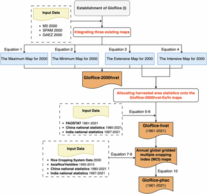
GloRice (v1.0) is a high-resolution global dataset mapping paddy rice harvested and physical areas from 1961 to 2021 at a 5-arcminute resolution. Developed by researchers from Sun Yat-sen University and the Chinese Academy of Sciences, it provides long-term data on rice-related variables for global modeling and estimation, including rice distribution, multiple cropping systems, water regimes, and residue treatment, capturing global and regional cultivation trends. The dataset integrates national and subnational statistics with established datasets (M3, SPAM, GAEZ) to generate annual rice distribution maps. It consists of three key components: (1) GloRice-2000hvst, a reference for the year 2000; (2) GloRice-hvst, annual harvested area maps; and (3) GloRice-phsc, annual physical area maps based on multiple cropping index data. Validation demonstrates strong accuracy at global, regional, and subnational levels, particularly for China, South Asia, and Southeast Asia. GloRice supports research in agriculture, climate modeling, and environmental sustainability, offering a valuable tool for assessing global rice production trends.
Viewed Articles
Xie H, Li J, Li T, Lu X, Hu Q, Qin Z | Source | Download |┬ĀGloRice (v1.0) is a high-resolution global dataset mapping paddy rice harvested and physical areas from 1961 to 2021 at a 5-arcminute resolut
Read More
Americas Group on Earth Observations (AmeriGEO) | Source | The AmeriGEO initiative fosters collaboration among Group on Earth Observations (GEO) members across the Americas to ensure decisions benefit
LCA Software Directory | ┬ĀThe Directory is an independent initiative run by Brussels-based LCA professionals. It aims to be a reliable source of market research, business news and investment insights
┬ĀClimate KIC is a European climate innovation community initiated by the European Institute of Innovation and Technology (EIT) that supports place-based climate action and net-zero transitions through
International Rice Research Institute (IRRI) |┬ĀRiceMoRe (Rice Activity Monitoring and Reporting) is Viet NamŌĆÖs national digital platform for monitoring rice production, integrating a web interface, mo
CGIAR| Source | ┬ĀThe Alliance of Bioversity International and CIAT, established in 2019 as part of CGIAR, is committed to transforming agrifood systems through research and innovation. Their unified s


