Search
Spatial–temporal Distribution of Global Production–Living–Ecological Space 2000–2020

Scientific Data| Source | Data   

Scientific Data is a peer-reviewed open-access journal for descriptions of datasets and research that advances the sharing and reuse of research data. Our primary content-type, the Data Descriptor, combines traditional narrative content with structured descriptions of data to provide a framework for data-sharing to accelerate the pace of scientific discovery. These principles are designed to align with and support the FAIR Principles for scientific data management and stewardship, which declare that research data should be Findable, Accessible, Interoperable and Reusable.

This dataset addresses a gap in global databases, providing a valuable resource for evaluating sustainable development goal coordination, considering economic, social, and ecological elements in the production-living-ecology space. The dataset was generated by researchers from University of Chinese Academy of Sciences from integrating global land cover data from GlobeLand30 and population density data from NASA for 2000, 2010, and 2020 to create a comprehensive global production-living-ecological space map. Verification using random sampling in ArcGIS and Google Earth images yielded high accuracy of 83.94 to 87%.


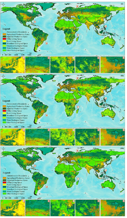
Fig. | Global production–life–ecological space classification in 2000 (I), 2010 (II), and 2020 (III).


Viewed Articles
Spatial–temporal Distribution of Global Production–Living–Ecological Space 2000–2020
Scientific Data| Source | Data   | Scientific Data is a peer-reviewed open-access journal for descriptions of datasets and research that advances the sharing and reuse of research data. Our primary co
Read More
Towards a National Ocean Account
Australian Bureau of Statistics | Source | Data |  In the context of global efforts to combat climate change and achieve net-zero emissions, understanding and managing the role of our ocean and coasta
Global Forest Carbon Database
ForestGEO Ecosystems & Climate Lab| Source | Data | Published research | The ForestGEO Ecosystems & Climate Lab operates within the Forest Global Earth Observatory (ForestGEO), a worldwide network of
FAO climate risk toolbox
Food and Agricultural Organiztion of the United Nations| Source | Data | Guide |The Climate Risk Toolbox (CRTB) is a freely accessible resource hosted on the Hand-in-Hand geospatial platform, develope
EuroCrops: The Largest Harmonized Open Crop Dataset Across the European Union
Technical University of Munich| Source | Data | EuroCrops, currently hosted by Technical University of Munich, is a valuable resource comprising geo-referenced agricultural cropland data from 16 Europ
Global Agro-Ecological Zones
Food and Agricultural Organiztion of the United Nations| Source | The Food and Agriculture Organization of the United Nations (FAO) and the International Institute for Applied Systems Analysis (IIASA)
TOP