FarmVibes.AI: Multi-Modal GeoSpatial ML Models for Agriculture and Sustainability
Microsoft | Source | Data | Guide |
FarmVibes.AI, developed by Microsoft, is a versatile platform designed for the development of multi-modal geospatial machine learning (ML) models tailored for agriculture and sustainability applications. The primary objective of this platform is to enable users to gain valuable insights by amalgamating and analyzing various geospatial and spatiotemporal datasets.
The platform offers a range of data ingestion and pre-processing workflows that assist users in preparing data for customized fusion models geared towards agricultural use cases. It provides convenient dataset downloaders, including resources like Sentinel 1 and 2 satellite imagery, US Cropland Data, USGS Elevation maps, NAIP imagery, NOAA weather data, and even private weather data from Ambient Weather. Users have the flexibility to incorporate their own rasterized datasets, such as drone imagery or additional satellite data, making them fusion-ready for utilization within FarmVibes.AI. Furthermore, the platform offers multiple data processing workflows that can be applied to the downloaded data, including index computation and data summarization.
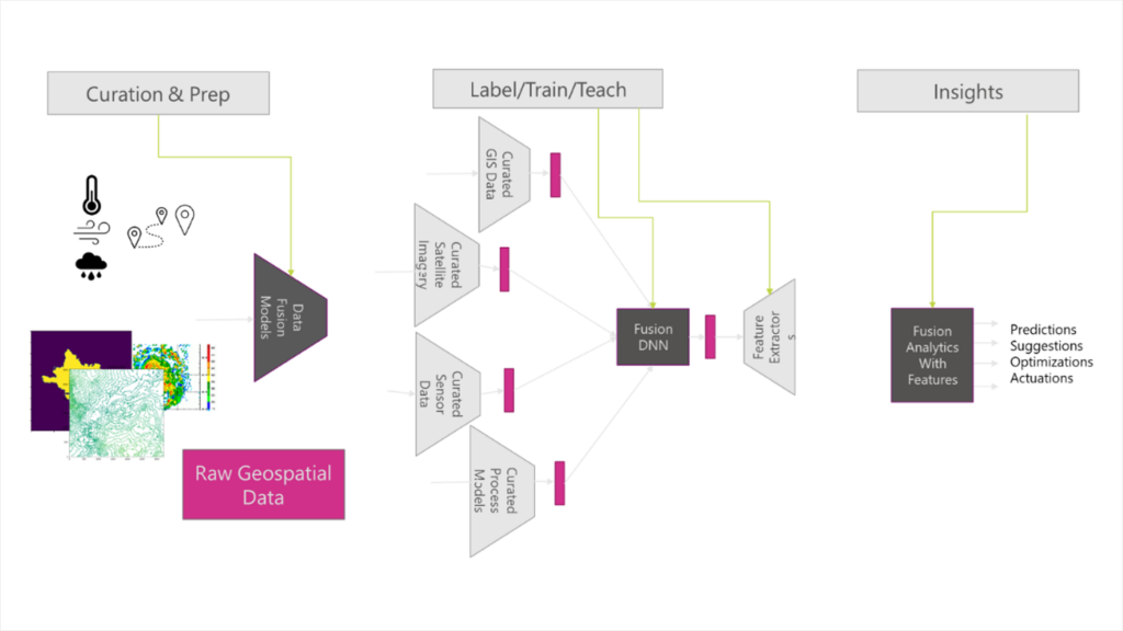
Fig. | Fusing datasets this way helps generate more robust insights.
Viewed Articles
Microsoft | Source┬Ā ┬Ā| Data┬Ā ┬Ā|┬ĀGuide |FarmVibes.AI, developed by Microsoft, is a versatile platform designed for the development of multi-modal geospatial machine learning (ML) models tailored for ag
Read More
GLAD platform | ┬ĀGLAD is the largest non-commercial directory and "search engine" for Life Cycle Assessment (LCA) datasets, indexing over 80,000 entries from independent global providers (nodes). Host
National Agriculture and Food Research Organization (NARO), Japan | Source | (In Japanese)The Model-Integrated Crop Weather Database provides key meteorological data, including solar radiation, humidi
GreenDelta | ┬ĀThe openLCA platform is a free, professional Life Cycle Assessment (LCA) and footprint software developed by GreenDelta since 2006. It is open source, powerful and widely used, offering
Funded by the European Union | Source | Flyer |┬ĀEU-FarmBook is a Horizon Europe initiative designed to support knowledge exchange in agriculture and forestry across the EU. It offers an interactive, m
Americas Group on Earth Observations (AmeriGEO) | Source | The AmeriGEO initiative fosters collaboration among Group on Earth Observations (GEO) members across the Americas to ensure decisions benefit


