Frontiers in Environmental Science | Apr 6, 2023
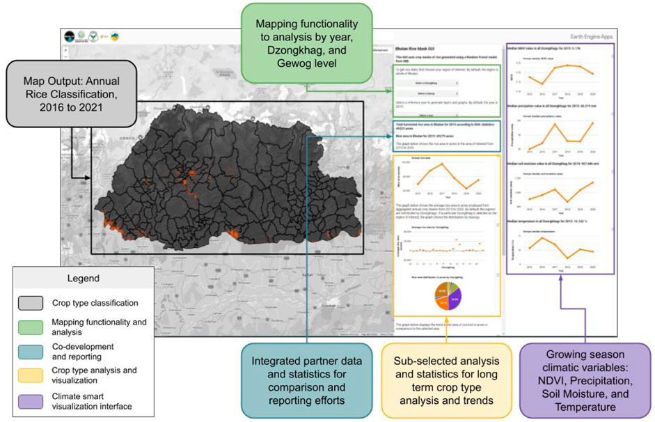
In Bhutan, creating accurate maps of annual crop types to support food security decision-making has been a significant challenge. The University of Alabama Huntsville, in collaboration with Bhutan, has undertaken a project to address this issue by advancing Science, Technology, Engineering, and Mathematics (STEM) in the country. Their joint effort has resulted in the development of a geospatial application called the Agricultural Classification and Estimation Service (ACES).
This study focuses on the co-development of a climate-smart crop type framework using Earth observation data and incorporates both modeling and training sample collection. The ACES web application and modeling software package allow stakeholders to utilize Earth observation data more effectively in their decision-making processes. The researchers also provide a transparent and replicable approach to overcome remote sensing limitations caused by topography and cloud cover, which is a common problem in Bhutan.
The study achieved promising results, with the Random Forest "LTE 555" model selected out of 3,600 possible models. It exhibited an overall test Accuracy of 85% and an F-1 Score of 0.88 for the year 2020. Independent validation of the model yielded an accuracy of 83% and an F-1 Score of 0.45 for the same year. The research provides valuable insights into model perturbation, hyperparameter tuning, and input features, which are crucial for future practitioners in this field.